Understanding the Technical Variances of Drone Inspection Services
LiDAR and Photogrammetry explained
In the field of 3D mapping and modelling, two prominent technologies stand out: LiDAR and photogrammetry. These methodologies are employed in drone inspection services to create detailed models and maps of environments, each offering its unique strengths and applications. To fully leverage these technologies, it’s crucial to understand their technical variances and how they complement different project needs.
This blog post delves into the intricacies of LiDAR and photogrammetry, exploring their underlying principles, advantages, and ideal use cases.
LiDAR – Active Measurement Using Lasers
LiDAR (Light Detection and Ranging) is an active measurement technique that utilises laser pulses to measure distances and generate precise 3D representations. By calculating the time, it takes for a laser pulse to bounce back after hitting a surface, LiDAR systems can accurately map out environments, even through dense vegetation or under challenging lighting conditions.
How LiDAR Works
Laser Pulses
LiDAR emits many laser pulses per second, with each pulse measuring the distance to the target surface.
Data Collection
The returning pulses create a point cloud that forms the basis of a 3D model, offering accurate dimensional data.
Capturing Fine Details
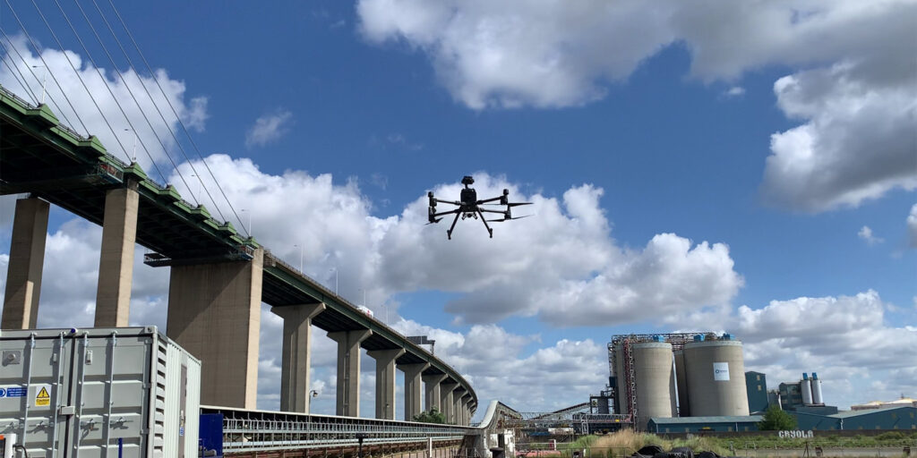
OR3D GEO employs the advanced Matrice 300 drone equipped with the Yellowscan Ultra 3 LiDAR unit, capable of emitting 640,000 lines per second and recording up to three echoes per shot. This high-frequency laser scanning ensures exceptional accuracy (+/- 25mm) and precision (+/- 30mm), making it possible to capture intricate details such as power cables. LiDAR’s ability to penetrate forest canopies and dense vegetation allows it to map the true ground level beneath, which is a key advantage for topographic mapping, forestry management, and large-scale infrastructure projects.
One of the standout benefits of LiDAR is its operational flexibility under all lighting conditions, including nighttime. The capability makes LiDAR ideal for applications that require continuous data collection, regardless of the weather or daylight availability. Another is its ability to provide information in real-time, enabling geospatial teams to check the data captured and send directly to the client.
Photogrammetry – Passive Measurement Using 2D Imagery
Photogrammetry is a passive measurement technique that uses high-resolution 2D photographs to analyse and measure objects and structures. By capturing images from multiple angles, photogrammetry creates detailed visual representations of surfaces, making it highly effective for condition surveys, detecting rust on bridges, and identifying concrete surface delamination. This method provides precise data for evaluating structural health, ensuring thorough documentation of surface defects, and facilitating proactive maintenance planning for critical infrastructure.
Principles of Photogrammetry
High-Resolution Cameras
OR3D GEO utilises the Matrice 300 drone fitted with a full-frame camera to capture images with exceptional clarity. Pre-programmed automated flight paths ensure consistent Ground Sampling Distance (GSD) coverage, enabling the capture of extremely detailed images. For applications such as crack detection, resolutions as fine as 1 millimetre GSD can be achieved.
Image Alignment
Using photogrammetry software like PIX4D, these images are aligned by identifying common points across multiple images, generating a dense point cloud.
Model Creation
The point cloud is then processed using geo-referenced data and image-matching algorithms, forming a highly detailed 3D model.
Utilising Photogrammetry for Crack Detection
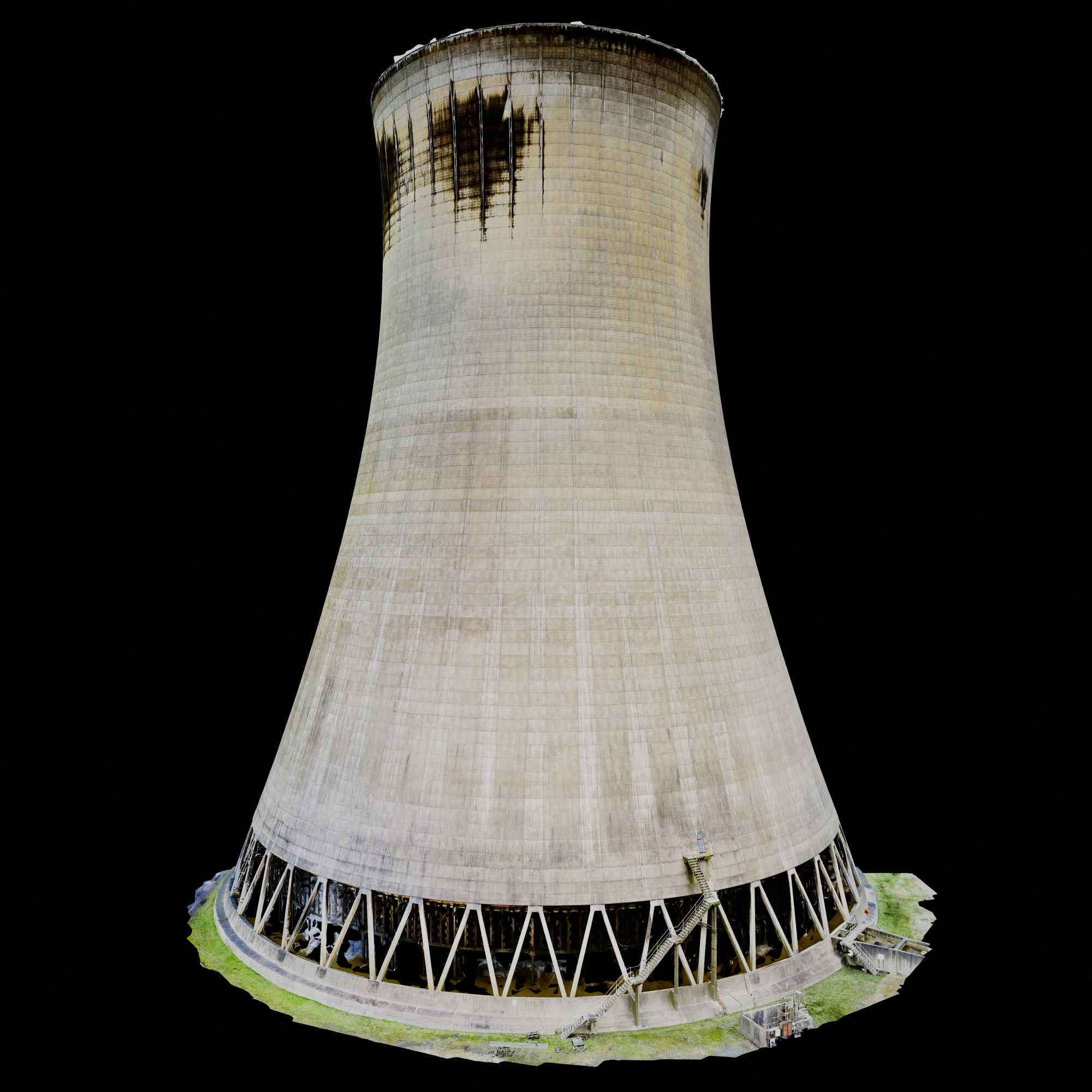
One of the key applications of photogrammetry in drone inspection services is structural integrity assessment. OR3D GEO was recently appointed to identify cracks and delamination on the surface of cooling towers using high-resolution photogrammetry techniques. This project involved capturing detailed images of the towers from multiple angles, which were then processed to create a comprehensive 3D model. This model enabled precise identification of surface imperfections, providing critical information for maintenance and safety assessments.
The use of photogrammetry for this project not only provided a non-invasive method for structural analysis but also delivered a valuable visual record for future inspections and maintenance planning.
Choosing the Right Technology for Your Project
Both LiDAR and photogrammetry are invaluable tools in the realm of 3D mapping and modelling, but each is best suited for different project requirements:
LiDAR is optimal for projects that involve complex environments, such as heavily vegetated areas or when accurate ground-level information is necessary. Its ability to operate in low-light conditions and penetrate through foliage makes it the go-to choice for forestry, topographic mapping, and infrastructure development projects. Additionally, LiDAR can produce 3D models faster compared to photogrammetry, which is beneficial for time-sensitive projects.
Photogrammetry, on the other hand, excels in projects requiring high visual detail, such as structural inspections, crack detection, site documentation, and construction monitoring. Its capability to produce visually rich models with fine texture details makes it ideal for use cases where surface-level features are a priority.
Round up
The technical variances between LiDAR and photogrammetry are crucial to consider when choosing the right tool for drone inspection services. LiDAR’s strength lies in its ability to provide highly accurate measurements under challenging environmental conditions, while photogrammetry shines in delivering detailed visual data for structural analysis and site documentation. Understanding these differences enables project teams to select the most effective technology based on specific requirements, ultimately enhancing the efficiency and quality of the 3D mapping and modelling outcomes.
By leveraging the unique capabilities of each technology, OR3D GEO can provide comprehensive drone inspection services tailored to meet diverse project needs, ensuring precise data collection and robust analysis for any environment or structure.


